Washtenaw County’s outdoor warning sirens are usually tested at noon the first Saturday of each month March through September. Due to a continuing threat of severe weather, today’s test has been cancelled.
Washtenaw County Emergency Operations Center: “SIREN TEST CANCELLED. SEVERE STORMS WITH 60 MPH WINDS, ISOLATED TORNADOES AND URBAN FLOODING ARE POSSIBLE TODAY/TONIGHT.”
Expect storms to develop and move through SE MI at 30 mph throughout the evening and into tonight. The risk of strong storms continues overnight.
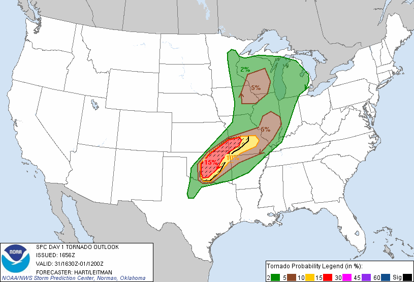
There is a slight chance of any storms that develop being severe; a 15% chance of damaging wind or large hail; and a small chance of isolated tornadoes.
Storms have developed over the western third of southern lower MI and are slowly moving west; additional development could occur in other areas of southern MI with little warning. Storms in northern Indiana tracking west-northwest are strong and at times severe; these might hit A2 or pass south of us.
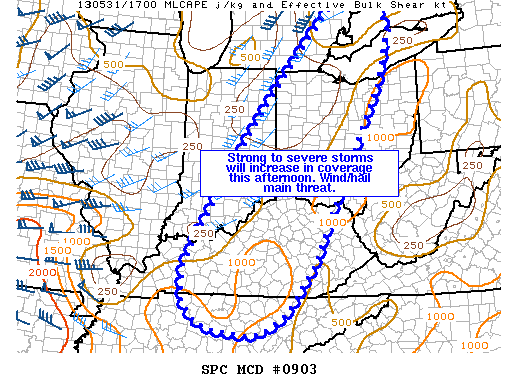
Ann Arbor is included in MD 903, which stretches from Nashville approximately up to Port Huron.
Within this area, thunderstorm activity is expected to increase throughout the afternoon, with organized clusters or lines of strong-to-severe storm are expected to form. These storms would bring strong winds and possibly damaging hail, along with the lightning and heavy rain that is expected with any strong storm system. We might (40% probability) see a severe thunderstorm watch for the area issued shortly.
SPC MD 903
MESOSCALE DISCUSSION 0903
   NWS STORM PREDICTION CENTER NORMAN OK
   1233 PM CDT FRI MAY 31 2013

   AREAS AFFECTED...FAR SE MI...WRN OH...FAR SE IND...CNTRL/ERN KY...N
   CNTRL TN

   CONCERNING...SEVERE POTENTIAL...WATCH POSSIBLE

   VALID 311733Z - 311900Z

   CORRECTED FOR AFFECTED AREA

   PROBABILITY OF WATCH ISSUANCE...40 PERCENT

   SUMMARY...THUNDERSTORM COVERAGE WILL INCREASE THROUGH THE AFTERNOON.
   LOOSELY ORGANIZED STRONG TO SEVERE STORM CLUSTERS WILL BE CAPABLE OF
   PRODUCING STRONG WINDS AND MARGINALLY SEVERE HAIL.

   DISCUSSION...SCATTERED THUNDERSTORMS WERE DEVELOPING IN AREA OF
   INCREASING ASCENT AHEAD OF UPPER SHORTWAVE IMPULSE MOVING ACROSS THE
   MID-MS VALLEY EARLY THIS AFTERNOON. POCKETS OF STRONGER HEATING
   ACROSS SE MI/WRN OHIO INTO PARTS OF CNTRL AND ERN KY HAS ALLOWED FOR
   WEAK DESTABILIZATION WITH SBCAPE VALUES AROUND 1000 J/KG. BULK SHEAR
   VALUES AROUND 20-40 KTS SHOULD LEAD TO AT LEAST SOME ORGANIZED
   CLUSTERS/LINE SEGMENTS. THE BEST LOCATIONS FOR THIS TO OCCUR WOULD
   BE ACROSS FAR SW MI /WHERE STORMS ARE CURRENTLY ONGOING/ INTO PARTS
   OF IND AND OHIO WHERE DEEP LAYER SHEAR IS A BIT STRONGER THAN
   FURTHER SOUTH INTO KY/TN. HOWEVER...A REMNANT MCV EVIDENT IN
   SATELLITE IMAGERY MOVING ACROSS THE LOWER OHIO VALLEY MAY SERVE TO
   FOCUS STRONGER THUNDERSTORM DEVELOPMENT THIS AFTERNOON ACROSS KY
   DESPITE WEAKER DEEP LAYER SHEAR. STRONG WINDS AND MARGINALLY SEVERE
   HAIL WILL BE THE MAIN THREATS WITH ANY ORGANIZED STORMS THAT CAN
   DEVELOP TODAY. TRENDS WILL BE MONITORED FOR POSSIBLE WW ISSUANCE.

   ..LEITMAN/HART.. 05/31/2013

   ATTN...WFO...RLX...CLE...MRX...JKL...ILN...DTX...LMK...IWX...
   GRR...OHX...IND...PAH...

   LAT...LON   35778565 35868653 36028704 36568743 37298738 37958704
               40308554 42028418 43628266 43478203 42768135 41478167
               39918246 37318371 36258449 35798517 35778565
Expect thunderstorms across the area this afternoon and evening; warm, moist, unstable air across SE MI will contribute to storms developing quickly and without much warning. (We’ve seen this already today with this line of storms.) The principal risks with these storms are probable damaging wind gusts and large hail, with a slight risk of isolated tornadoes. Also expect locally heavy rainfall. We have a slight risk of some of these storms becoming severe, particularly in the late afternoon.
Washtenaw County emergency operations center: “SEVERE STORMS WITH 65 MPH WINDS, ONE INCH HAIL, ISOLATED TORNADOES AND URBAN FLOODING ARE POSSIBLE TODAY AND TONIGHT.”
NWS Detroit:
THERE IS A CHANCE OF THUNDERSTORMS OVER ALL OF SOUTHEAST MICHIGAN
TODAY WITH THUNDERSTORMS LIKELY TONIGHT. THERE IS A SLIGHT RISK
OF SEVERE WEATHER BOTH TODAY AND TONIGHT...BUT WITH THE BEST
CHANCE BEING DURING THE WARMEST PART OF THE LATE AFTERNOON INTO
EARLY EVENING. THE PRIMARY HAZARD WILL BE HEAVY DOWNPOURS AND
DAMAGING WIND GUSTS NEAR 60 MPH...BUT HAIL UP TO 1 INCH IS ALSO
POSSIBLE AS STORMS MOVE FROM SOUTHWEST TO NORTHEAST AT 30 MPH.

WARM AND HUMID AIR WILL REMAIN IN PLACE OVER LOWER MICHIGAN TODAY
THROUGH TONIGHT. THE POTENTIAL FOR SEVERE WEATHER WILL BE TIED TO
AFTERNOON TEMPERATURE TRENDS AFTER SHOWERS AND THUNDERSTORMS
DURING THE MORNING EITHER DISSIPATE OR EXIT THE AREA. THIS IS
EXPECTED TO RESULT IN JUST SCATTERED COVERAGE UNTIL LATER TONIGHT
WHEN CLUSTERS OF ACTIVITY WILL MOVE IN FROM THE MIDWEST AND OHIO
VALLEY. COVERAGE WILL BE GREATER BY THEN BUT INTENSITY WILL BE
DECREASING DURING THE OVERNIGHT HOURS.
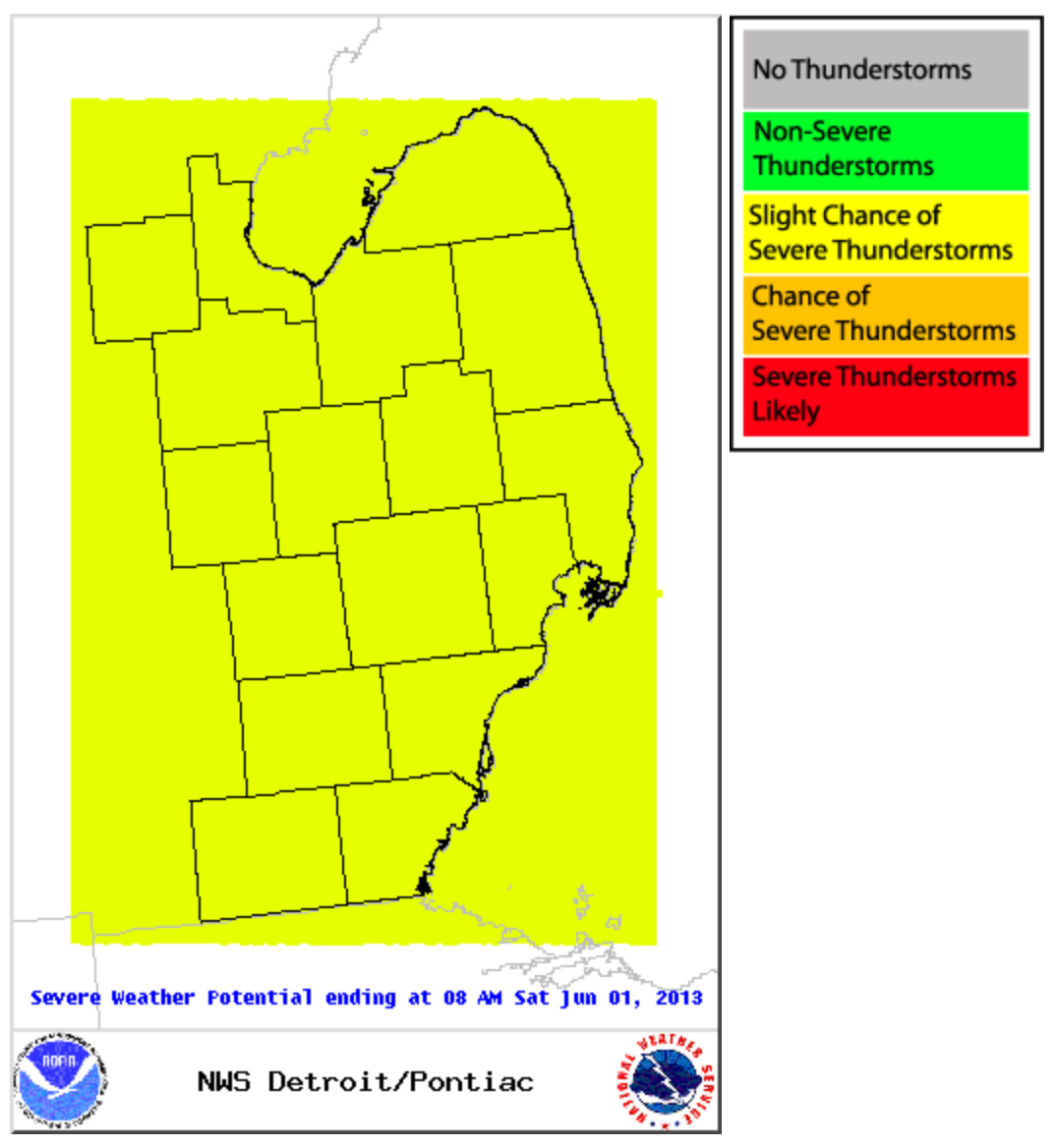
NWS Detroit area severe weather outlook May 30, 2013
We’ve already seen one severe storm in the area, and as more storms continue to develop over the next 10 hours, some will be severe.
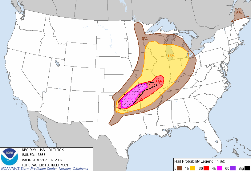
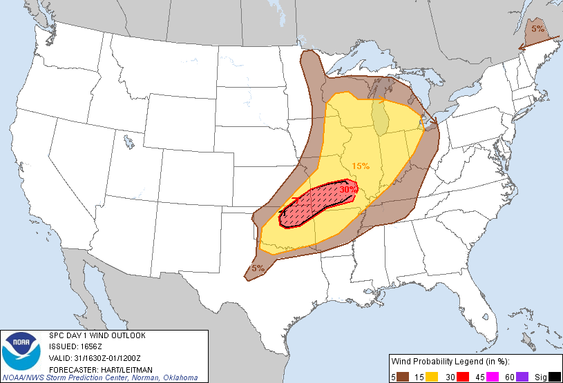
Our outlook today shows us at slight risk for severe convective weather; a 15% chance of large hail; a 15% chance of damaging wind; and a 2% chance of tornadoes.
Hail outlook May 31, 2013 12:30pm onwardWind outlook May 31, 2013 12:30pm onwardTornado outlook May 31, 2013 12:30pm onward
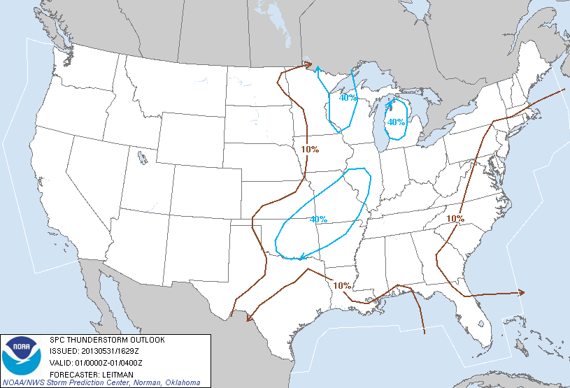
Looking forward, the SPC’s thunderstorm outlook for 4-8pm shows us around a 40% risk for thunderstorms; I believe this is conservative given what we’ve already seen today. From 8pm-midnight, they show us just outside a 40% risk area, and again from midnight-8am; again, I expect thunderstorms in are area at least through midnight.
Thunderstorm Outlook May 31, 2013 4-8pmThunderstorm Outlook May 31, 2013 8pm-midnight