Thunderstorms expected as cold front moves through; severe storms are possible

Update 5:37pm: heavy cloud cover helped prevent this system from developing severe storms in Ann Arbor. The city will see light rain on and off into the evening.

As a cold front moves through southern Michigan this afternoon into the evening, we will see rain and many thunderstorms scattered across the region.

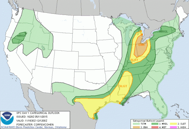
Some of these storms will be strong, and the National Weather Service has rated our area at an “enhanced” risk of severe storms for today. Image follows.

(That’s right in the middle of the scale: it goes “none”, “marginal”, “slight”, “enhanced”, “moderate”, “high”.)

Day 1 Categorical Outlook May 11


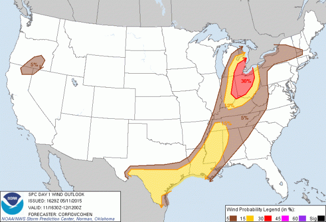
Along with these storms, we can expect strong winds and localized heavy rainfall. Damaging hail is possible. There is a very small chance of tornados predicted with today’s storms.

The outlook for damaging winds today:

day1probotlk_1630_wind

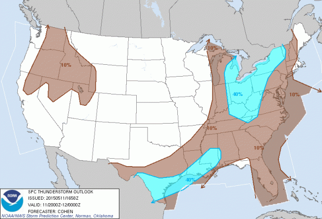
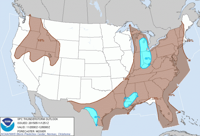
The thunderstorm outlook for today shows a high potential for storms from 4-8pm:

enh_2000-2

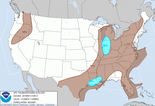
Update: these following thunderstorm outlooks became outdated while this post was being written. Finally, the thunderstorm outlooks for noon-4pm and then 4-8pm follow, indicating late afternoon is when we’re likely to see the stronger storms:
enh_1600


enh_2000

Snow Condition Yellow

Washtenaw County is now at Snow Condition Yellow. Here’s what that means, and what we’ll be dealing with for the rest of this storm.

We’ve been under a winter storm warning since yesterday. That means “At least 6 inches of snow over a 12 hour period &/or significant amounts of freezing rain and gusty winds can be expected soon.” Winter storm advisories, watches, and warnings are issued by the National Weather Service in Detroit.

Washtenaw County’s Emergency Services Division will sometimes issue local travel bulletins. Snow Condition Yellow, which we’ve been in since about 5pm, means “Hazardous driving conditions are widespread with heavy snow or ice, drifting, and limited visibility. Traffic is moving at reduced speeds with major highways being maintained in fair condition, but local roads may be impassable. Motorists are urged that if they must drive, use extreme care and allow for a significant drive time.”

Basically: your local roads are going to be nearly impossible, and highways only just usable. Blowing snow and heavy ice are making driving anywhere now dangerous. Do not drive unless you absolutely must, and be extremely cautious if you do. We’re in Snow Condition Yellow until noon tomorrow.

For those curious, all this information comes straight from the county’s website. You can also learn what Snow Condition Red is there.

Now, to the forecast. As of 5pm, according to the county, we’ve seen more than 6 inches of snow, blowing snow is common, and “numerous” accidents have been reported. The NWS predicts 6 to 8 more inches before the storm ends, around sunrise on Monday; snowfall rates near 1 inch per hour are expected. Winds will persist between 20-30 miles per hour.

Please, everyone, stay safe. The roads really are in bad shape.

We’ll continue monitoring the storm here at ArborWX HQ and will post if it gets worse.

A Rainy, Windy Christmas

The winter storm we discussed previously is close enough now for the NWS to make some predictions. I’ll recap what we can expect over the next several days:

Starting tonight, we’ll see rain showers and cloudy, foggy conditions. Wednesday — Christmas Even — will be quite rainy, with a high temperature in the upper 40s or low 50s. Wednesday will also see wind start to pick up, and as we move into Wednesday night it’ll be rainy and wind gusts could reach 40-45 mph. Wednesday night it’ll be cooler; we might get some light snow overnight.

Christmas Day, we shouldn’t see much precipitation, but it’ll be breezy and cooler, with temperatures in the 30s.

Winter storm possible this Tuesday and Christmas Eve

Details are murky at this point, but Michigan will probably see strong wind, rain/freezing rain and snow between Monday night and Wednesday, and into Christmas Day.

Starting Monday night, a weak storm system is expected to develop over the northern plains and be absorbed by a stronger system moving up from the south.

The timing, location, track and intensity of this storm are difficult to estimate accurately at this time, but the Great Lakes region can expect to see the strongest part of the storm. Earlier in the storm — Monday night or Tuesday — we’re likely to see heavy, cold rain, and on Wednesday into Christmas Day we can expect some snow accumulation. Gusting wind will make it difficult to keep roads clear and blowing snow will affect visibility for drivers on Tuesday and Wednesday.

If you’re planning to travel next week, keep an eye on weather forecasts. Plan to travel on Monday, before the storm is predicted to hit southeastern Michigan.

ArborWX will track this as it develops; follow @ArborWX on Twitter for more frequent updates than are posted on the blog.

The outlook received from the Washtenaw County EOC follows.

HAZARDOUS WEATHER OUTLOOK
NATIONAL WEATHER SERVICE DETROIT/PONTIAC MI
VIA WASHTENAW COUNTY EMERGENCY OPERATIONS CENTER
251 PM EST FRI DEC 19 2014
 
A POWERFUL WINTER STORM IS EXPECTED TO DEVELOP ACROSS THE 
EASTERN UNITED STATES ON TUESDAY AND WEDNESDAY. ITS IMPACTS 
INCLUDING HOLIDAY TRAVEL...WILL BE FELT IN THE GREAT LAKES 
REGION FROM TUESDAY INTO CHRISTMAS DAY. THERE IS 
CONSIDERABLE UNCERTAINTY IN THE EXACT TRACK AND EVENTUAL 
STRENGTH OF THIS STORM. THESE UNCERTAINTIES COULD HAVE A 
DRAMATIC AFFECT ON THE CHARACTER OF THE WEATHER FOR 
SOUTHEAST MICHIGAN FROM TUESDAY TO CHRISTMAS DAY.
 
AT THIS TIME...THE STORM IS EXPECTED TO BE STRONGEST OVER 
THE GREAT LAKES REGION. THE MOST LIKELY WEATHER HAZARD FOR 
SOUTHEAST MICHIGAN FROM THIS POWERFUL STORM IS THE POTENTIAL 
TO PRODUCE SIGNIFICANT WIND GUSTS FROM TUESDAY NIGHT INTO 
CHRISTMAS MORNING. SOUTHEAST MICHIGAN HAS THE POTENTIAL TO 
SEE LOCALLY HEAVY RAINFALL ON THE WARMER SIDE OF THE STORM 
FROM TUESDAY INTO WEDNESDAY...BUT ALSO HAS THE POTENTIAL 
FOR SOME SNOW ACCUMULATIONS ON THE COLDER SIDE OF THE STORM 
FROM LATE WEDNESDAY INTO CHRISTMAS MORNING.