Severe thunderstorm warning for southern Washtenaw County (including southern Ann Arbor) until 2:15pm

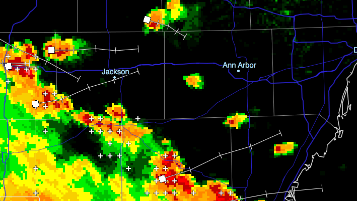
The NWS Detroit has issued a severe thunderstorm warning for the southern half of Washtenaw County until 2:15pm. This storm brings 1.25-inch (large!) hail and 60mph wind gusts and heavy rain. The worst of this storm will pass just south of Ann Arbor, around and south of Saline.

Full warning text follows

999
WUUS53 KDTX 101714
SVRDTX
MIC161-101815-
/O.NEW.KDTX.SV.W.0060.130710T1714Z-130710T1815Z/

BULLETIN - IMMEDIATE BROADCAST REQUESTED
SEVERE THUNDERSTORM WARNING
NATIONAL WEATHER SERVICE DETROIT/PONTIAC MI
114 PM EDT WED JUL 10 2013

THE NATIONAL WEATHER SERVICE IN DETROIT/PONTIAC HAS ISSUED A

* SEVERE THUNDERSTORM WARNING FOR...
  SOUTHERN WASHTENAW COUNTY IN SOUTHEAST MICHIGAN...

* UNTIL 215 PM EDT

* AT 109 PM EDT...A SEVERE THUNDERSTORM WAS LOCATED NEAR
  MANCHESTER...AND MOVING EAST AT 20 MPH.

  HAZARD...HALF DOLLAR SIZE HAIL AND 60 MPH WIND GUSTS.

  SOURCE...RADAR INDICATED.

  IMPACT...HAIL DAMAGE TO VEHICLES IS EXPECTED. EXPECT WIND DAMAGE TO
           ROOFS...SIDING AND TREES.

* THE SEVERE THUNDERSTORM WILL BE NEAR...
  BRIDGEWATER AROUND 125 PM EDT.
  SALINE AROUND 145 PM EDT.
  PITTSFIELD TOWNSHIP AROUND 155 PM EDT.
  MILAN AROUND 200 PM EDT.
  WHITTAKER AND WILLIS AROUND 215 PM EDT.

THE WARNING INCLUDES AREAS SURROUNDING THESE LOCATIONS...
  WILLIS...             YPSILANTI...          SALINE...
  MILAN...              MANCHESTER...

PRECAUTIONARY/PREPAREDNESS ACTIONS...

FOR YOUR PROTECTION MOVE TO AN INTERIOR ROOM ON THE LOWEST FLOOR OF A
BUILDING.

&&

LAT...LON 4221 8413 4228 8354 4209 8355 4209 8371
      4208 8372 4208 8376 4208 8397 4207 8414
TIME...MOT...LOC 1714Z 274DEG 17KT 4212 8397

HAIL...1.25IN
WIND...60MPH

$$

Thunderstorms expected this evening through tonight; slight severe potential (July 9)

NWS-DTX Composite Reflectivity crop July 9, 2013 4:28pm

A line of thunderstorms has developed in northern Ohio and western Michigan and is moving our way. The line can be expected in Ann Arbor in roughly an hour; isolated storm cells may give us some rain before then. These storms are not currently severe, but they are expected to continue developing as they encounter the warm, humid air over southeast MI. Some cells in this line, particularly a strong one which will pass south of Ann Arbor, have produced strong winds, heavy rain, and small hail.

Looking forward, thunderstorms are likely across extreme southeastern Michigan tonight through early Wednesday morning. It is difficult to predict exactly when (and if) storms will hit downtown Ann Arbor specifically.

Heavy rain is expected with some storms across tonight. Warm and humid air across the area will fuel storm development tonight, and there is a slight risk of severe weather. Damaging wind is the most likely threat tonight, accompanied by the possibility of one inch hail.

The strongest storms tonight, and therefore the worst wind and hail threats, are likely to be in extreme southern MI and northern OH, just missing Ann Arbor. But we can still expect some thunderstorms, with slight severe potential.

Here’s a helpful afternoon briefing from NWS Detroit.

The relevant part of today’s hazardous weather outlook:

THUNDERSTORMS ARE LIKELY TONIGHT...MAINLY DURING THE LATE EVENING
THROUGH SUNRISE WEDNESDAY...AND OVER ALL OF SOUTHEAST MICHIGAN.
THERE IS A SLIGHT RISK OF SEVERE WEATHER WITH DAMAGING WIND THE
PRIMARY HAZARD. THE STRONGEST STORMS WILL BE CAPABLE OF WIND GUSTS
TO 60 MPH OR GREATER. ONE INCH DIAMETER HAIL IS ALSO POSSIBLE ALONG
WITH HEAVY RAINFALL. STORM MOTION WILL BE WEST TO EAST AT 40 MPH.

LOW PRESSURE OVER THE PLAINS AND MIDWEST WILL LEAD TO THUNDERSTORM
FORMATION THROUGH TODAY. THESE STORMS ARE EXPECTED TO GROW INTO A
LINE AND MOVE INTO LOWER MICHIGAN TONIGHT. CONTINUED WARM AND HUMID
AIR IN PLACE OVER SOUTHEAST MICHIGAN WILL FUEL THE STORMS AS THEY
MOVE THROUGH THE REGION. THE BEST CHANCE OF SEVERE WEATHER WILL BE
FROM ABOUT MIDNIGHT THROUGH SUNRISE WEDNESDAY.


Thunderstorms expected across southern MI this afternoon; some severe storm risk (July 8)

Thunderstorm development is anticipated across southern lower Michigan this afternoon, as storms currently over Lake Michigan move east and encounter warm, unstable air over our state. Storms will move west to east at 30mph. Some of these storms are expected to be strong, with a chance of some storm cells becoming severe.

It is difficult to predict exactly if/when strong storms will arrive specifically in Ann Arbor, but we can expect rain and thunderstorms between 2pm through the evening.

With these storms, we have a 15% chance of damaging winds, and a 5% chance of large hail. Some storms will produce heavy rainfall. The tornado threat for today is minimal.

Washtenaw County Emergency Operations Center:

SEVERE THUNDERSTORMS WITH 60 MPH WINDS AND 1 INCH HAIL ARE POSSIBLE THROUGH THIS EVENING.

Looking forward to Tuesday, we can again expect afternoon thunderstorms, with a moderate risk of severe storms with damaging winds and large hail.

Additional reading: NWS Detroit’s briefing slides for today