During a weather event like today’s, I will provide frequent updates and information via Twitter @ArborWX. That Twitter account will usually be more up-to-date than the blog, simply because it’s easier and faster to get up-to-the-minute information out to people.
That said, I will be out of town this weekend, starting now. Expect regular ArborWX updates to resume at some point on Monday.
A line of strong thunderstorms stretching approximately from Jackson to Toledo is moving northeast — exactly toward Ann Arbor — at 20mph. I expect them to arrive in Ann Arbor between 9:30 and 11pm this evening.
The storms are strong now, but not classified as severe. They are capable of producing heavy downpours, pea sized hail, 30mph wind gusts (capable of blowing trash bins and other light objects), and some cloud-to-ground lightning. They will likely remain the same strength or weaken somewhat before they arrive in Ann Arbor.
The cell over Adrian right now (exactly on track to hit A2) is currently the strongest cell in this line, and is currently producing some hail. It is best to be indoors when these storms arrive in Ann Arbor.
KDTX Composite Reflectivity, June 25 2013 8:24pm. Plus marks indicate lightning; white lines with tick marks indicate storm direction.
The Washtenaw County emergency operation center has this to say about severe weather in the area tonight:
ISOLATED SEVERE STORMS WITH 60 MPH WINDS, ONE INCH HAIL AND HEAVY RAINFALL ARE POSSIBLE THROUGH THURSDAY MORNING.
Full special weather statement from NWS Detroit follows:
WWUS83 KDTX 270022
SPSDTX

SPECIAL WEATHER STATEMENT
NATIONAL WEATHER SERVICE DETROIT/PONTIAC MI
822 PM EDT WED JUN 26 2013

MIZ075-076-082-083-270115-
LENAWEE-MONROE-WASHTENAW-WAYNE-
822 PM EDT WED JUN 26 2013

...SPECIAL WEATHER STATEMENT...

AT 817 PM EDT...NATIONAL WEATHER SERVICE DOPPLER RADAR INDICATED
STRONG THUNDERSTORMS ALONG A LINE EXTENDING FROM 16 MILES WEST OF
MANCHESTER TO 8 MILES SOUTH OF TECUMSEH TO 10 MILES SOUTH OF
MONROE...MOVING NORTHEAST AT 20 MPH.

HEAVY DOWNPOURS WITH MINOR FLOODING WILL BE POSSIBLE WITH THESE
STORMS. PEA SIZE HAIL AND WIND GUSTS AROUND 30 MPH AS WELL AS
OCCASIONAL CLOUD TO GROUND LIGHTNING ARE ALSO POSSIBLE.

* THUNDERSTORMS WILL BE NEAR...
 PETERSBURG BY 830 PM EDT...
 TECUMSEH BY 835 PM EDT...
 IDA AND BRITTON BY 840 PM EDT...
 DUNDEE AND CLINTON BY 845 PM EDT...
 MONROE AND MANCHESTER BY 855 PM EDT...
 MAYBEE BY 905 PM EDT...


GUSTY WINDS MAY CAUSE SMALL OBJECTS SUCH AS TRASH BINS TO BLOW
AROUND. STAY AWAY FROM HIGH OBJECTS OUTDOORS SUCH AS TREES. SEEK
SHELTER IN A STURDY STRUCTURE UNTIL THESE STORMS HAVE PASSED.

$$

RK
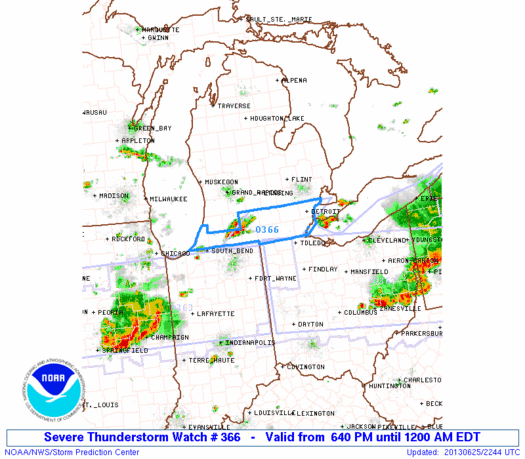
The threat of damaging winds and large hail is increasing (read MD 1227 for detailed background information), and the SPC has issued a severe thunderstorm watch for southern MI. The watch is effective until midnight.
A watch means that conditions are right for severe thunderstorms to form in and close to the watch area (and we have seen some storms form in SW MI very quickly this afternoon).
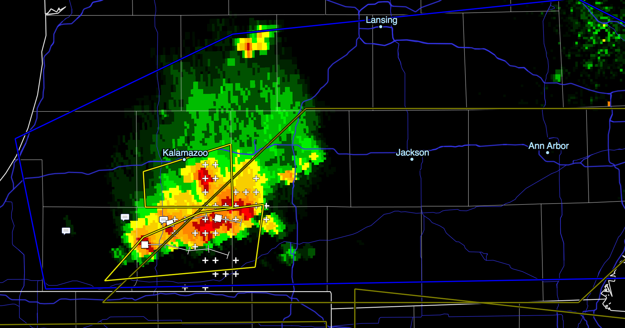
The watch is in response to storms which developed quickly in SW Michigan around 5pm today, and shortly thereafter became severe. They are moving west, relatively slowly right now, and are expected to persist or continue developing. They are already severe, with significant lightning, heavy rainfall, and tops at 55,000 feet.
KDTX Composite Reflectivity, SW MI crop, 6:41pm EDT June 25 2013
Primary threats from storms in this area are:
damaging winds (70mph gusts possible)
some large hail up to 1.5 inches in diameter is possible
few tornadoes are possible
Watch 366, effective until midnight EDT (Wednesday morning). The blue area in southern MI is the watch area.
SEL6

   URGENT - IMMEDIATE BROADCAST REQUESTED
   SEVERE THUNDERSTORM WATCH NUMBER 366
   NWS STORM PREDICTION CENTER NORMAN OK
   640 PM EDT TUE JUN 25 2013

   THE NWS STORM PREDICTION CENTER HAS ISSUED A

   * SEVERE THUNDERSTORM WATCH FOR PORTIONS OF
     SOUTHERN LOWER MICHIGAN
     LAKE ERIE

   * EFFECTIVE THIS TUESDAY NIGHT FROM 640 PM UNTIL MIDNIGHT EDT.

   * PRIMARY THREATS INCLUDE...
     SEVERAL DAMAGING WIND GUSTS TO 70 MPH POSSIBLE
     A FEW LARGE HAIL EVENTS TO 1.5 INCHES IN DIAMETER POSSIBLE
     A FEW TORNADOES POSSIBLE

   THE SEVERE THUNDERSTORM WATCH AREA IS APPROXIMATELY ALONG AND 60
   STATUTE MILES EAST AND WEST OF A LINE FROM 15 MILES NORTH OF ANN
   ARBOR MICHIGAN TO 40 MILES SOUTH SOUTHWEST OF JACKSON MICHIGAN.
   FOR A COMPLETE DEPICTION OF THE WATCH SEE THE ASSOCIATED WATCH
   OUTLINE UPDATE (WOUS64 KWNS WOU6).

   PRECAUTIONARY/PREPAREDNESS ACTIONS...

   REMEMBER...A SEVERE THUNDERSTORM WATCH MEANS CONDITIONS ARE
   FAVORABLE FOR SEVERE THUNDERSTORMS IN AND CLOSE TO THE WATCH
   AREA. PERSONS IN THESE AREAS SHOULD BE ON THE LOOKOUT FOR
   THREATENING WEATHER CONDITIONS AND LISTEN FOR LATER STATEMENTS
   AND POSSIBLE WARNINGS. SEVERE THUNDERSTORMS CAN AND OCCASIONALLY
   DO PRODUCE TORNADOES.

   &&

   OTHER WATCH INFORMATION...CONTINUE...WW 361...WW 362...WW
   363...WW 364...WW 365...

   DISCUSSION...TSTMS NOW FORMING IN SW LWR MI...ALONG INTERSECTION OF
   LAKE BREEZE BOUNDARY AND W-E OUTFLOW BOUNDARY FROM EARLIER
   STORMS...EXPECTED TO PERSIST AND POSSIBLY STRENGTHEN AS LOW-LVL
   CONVERGENCE/HEATING CONTINUE ACROSS REGION. AREA VWP DATA WITH
   MODERATE...UNIDIRECTIONAL DEEP WLY WINDS SUGGEST POTENTIAL FOR A FEW
   SUSTAINED STORMS/BOWING SEGMENTS CAPABLE OF DMGG WIND...MARGINALLY
   SVR HAIL...AND PERHAPS A TORNADO THROUGH MID TO LATE EVE AS THE
   ACTIVITY MOVES/PROPAGATES MAINLY EWD.

   AVIATION...A FEW SEVERE THUNDERSTORMS WITH HAIL SURFACE AND ALOFT
   TO 1.5 INCHES. EXTREME TURBULENCE AND SURFACE WIND GUSTS TO 60
   KNOTS. A FEW CUMULONIMBI WITH MAXIMUM TOPS TO 550. MEAN STORM
   MOTION VECTOR 27035.


   ...CORFIDI
The threat of thunderstorms for this afternoon/evening is still present, but somewhat smaller than predicted this morning. We still have a small threat of severe weather, but that has also diminished somewhat since this morning; the primary threat from most of these storms will be heavy rain, with only a small chance of damaging wind or large hail.
We can expect scattered storms this afternoon/evening across southern/SE MI, with only a slight chance of any storms becoming severe. Severe storms are more likely south of I-94, so Ann Arbor should probably see only rain and average thunderstorms, if anything at all. Predicting exactly if/when any of these storms will hit downtown Ann Arbor specifically is difficult.
Several rounds of thunderstorms are likely across the area this afternoon into tonight. Heavy rain will be posible with some storms. There is a slight risk that some of these storms will be severe, with the primary threats being damaging winds (60mph gusts possible) and large hail. The best potential for severe storms is this afternoon and early evening. A tornado threat is minimal in our area. I wouldn’t worry about that today; straight-line wind gusts are a much more likely problem.
.DAY ONE...TODAY AND TONIGHT

A MIDLEVEL DISTURBANCE WILL PASS THROUGH THE CENTRAL GREAT LAKES
TODAY AND TONIGHT...MAKING THUNDERSTORMS LIKELY ACROSS THE AREA.
THERE IS A SLIGHT RISK FOR SEVERE WEATHER...WITH DAMAGING WIND
GUSTS TO 60 MPH AND HAIL TO ONE INCH IN DIAMETER POSSIBLE. STORM
MOTION WILL BE WEST TO EAST AT 30 MPH.
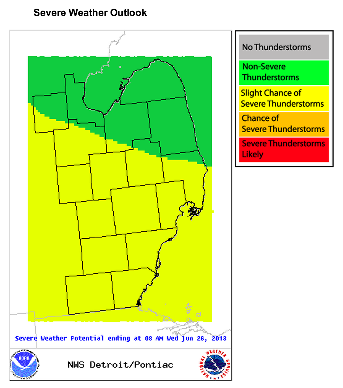
Updated SPC outlooks are here. We are on the border of the 30% probability areas for damaging wind and large hail. The thunderstorm outlook shows our risk dropping after 8pm, though we can still expect some storms across southern MI tonight.
Severe weather outlook via NWS Detroit June 25, 2013
We will continue to see rounds of thunderstorms through Wednesday. (There is continued severe weather potential Wednesday, with risk of damaging winds and large hail, and a slightly increased tornado risk.)