Briefing: Thunderstorms expected this afternoon and evening; slight severe potential

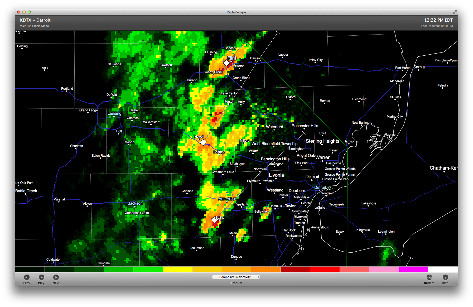
Expect thunderstorms across the area this afternoon and evening; warm, moist, unstable air across SE MI will contribute to storms developing quickly and without much warning. (We’ve seen this already today with this line of storms.) The principal risks with these storms are probable damaging wind gusts and large hail, with a slight risk of isolated tornadoes. Also expect locally heavy rainfall. We have a slight risk of some of these storms becoming severe, particularly in the late afternoon.

Washtenaw County emergency operations center: “SEVERE STORMS WITH 65 MPH WINDS, ONE INCH HAIL, ISOLATED TORNADOES AND URBAN FLOODING ARE POSSIBLE TODAY AND TONIGHT.”

NWS Detroit:

THERE IS A CHANCE OF THUNDERSTORMS OVER ALL OF SOUTHEAST MICHIGAN
TODAY WITH THUNDERSTORMS LIKELY TONIGHT. THERE IS A SLIGHT RISK
OF SEVERE WEATHER BOTH TODAY AND TONIGHT...BUT WITH THE BEST
CHANCE BEING DURING THE WARMEST PART OF THE LATE AFTERNOON INTO
EARLY EVENING. THE PRIMARY HAZARD WILL BE HEAVY DOWNPOURS AND
DAMAGING WIND GUSTS NEAR 60 MPH...BUT HAIL UP TO 1 INCH IS ALSO
POSSIBLE AS STORMS MOVE FROM SOUTHWEST TO NORTHEAST AT 30 MPH.

WARM AND HUMID AIR WILL REMAIN IN PLACE OVER LOWER MICHIGAN TODAY
THROUGH TONIGHT. THE POTENTIAL FOR SEVERE WEATHER WILL BE TIED TO
AFTERNOON TEMPERATURE TRENDS AFTER SHOWERS AND THUNDERSTORMS
DURING THE MORNING EITHER DISSIPATE OR EXIT THE AREA. THIS IS
EXPECTED TO RESULT IN JUST SCATTERED COVERAGE UNTIL LATER TONIGHT
WHEN CLUSTERS OF ACTIVITY WILL MOVE IN FROM THE MIDWEST AND OHIO
VALLEY. COVERAGE WILL BE GREATER BY THEN BUT INTENSITY WILL BE
DECREASING DURING THE OVERNIGHT HOURS.

NWS Detroit notes that the episodic nature of these thunderstorms creates forecasting challenges in regards to exact timing. Additional reading: NWS Detroit briefing slides for today.

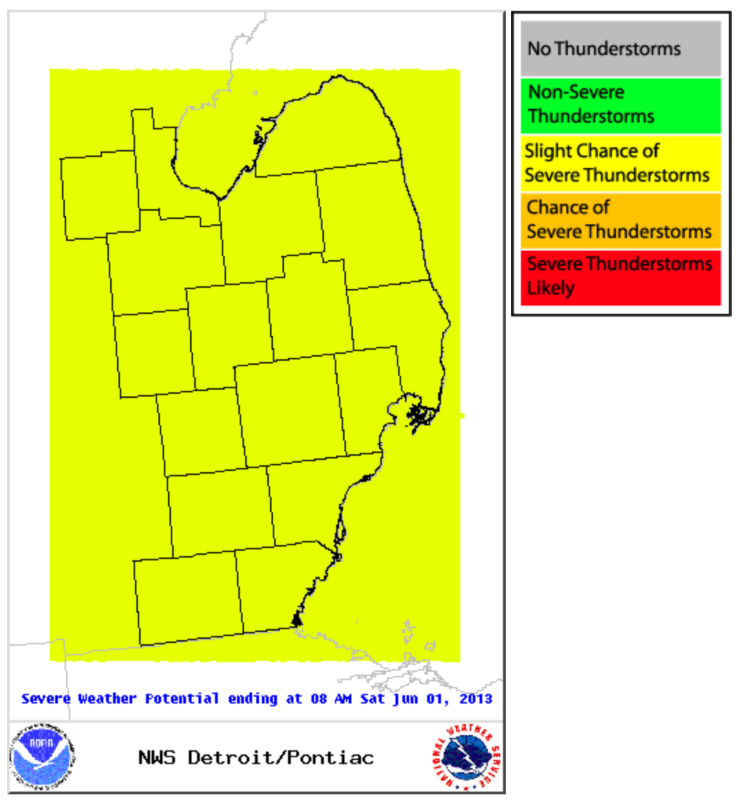
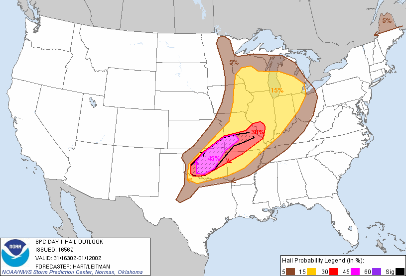
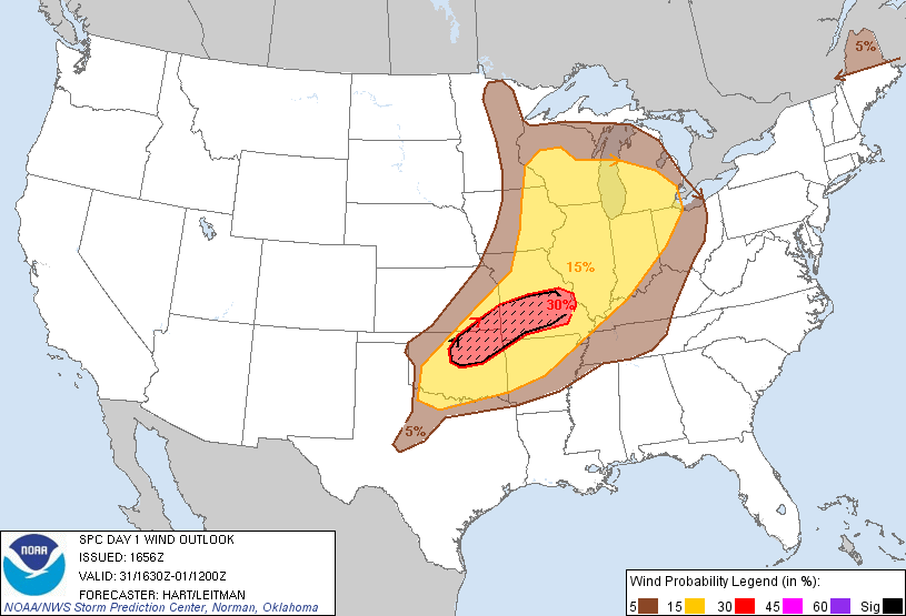
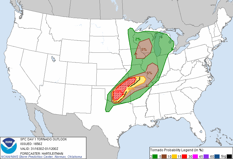
Today’s severe weather outlook shows us at slight risk for severe thunderstorms:

NWS Detroit area severe weather outlook May 30, 2013

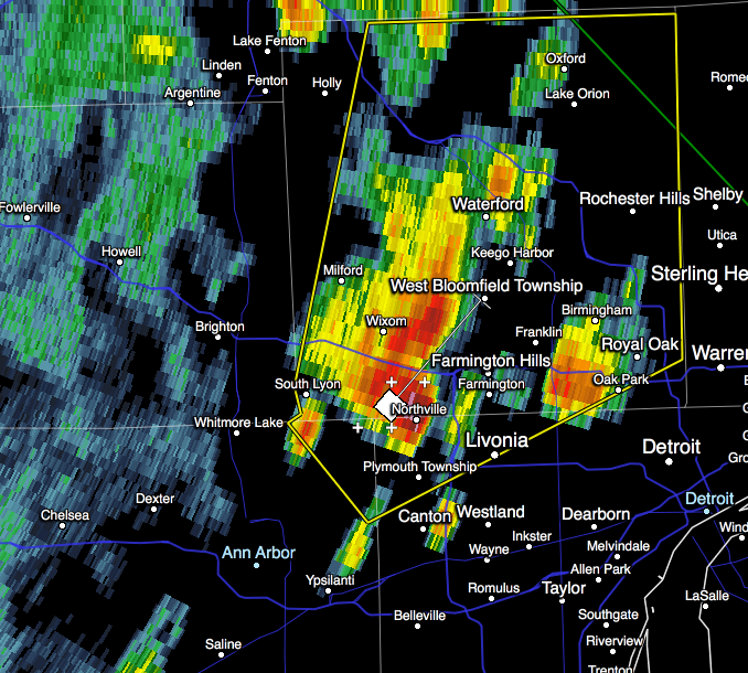
We’ve already seen one severe storm in the area, and as more storms continue to develop over the next 10 hours, some will be severe.

Our outlook today shows us at slight risk for severe convective weather; a 15% chance of large hail; a 15% chance of damaging wind; and a 2% chance of tornadoes.

Hail outlook May 31, 2013 12:30pm onward
Wind outlook May 31, 2013 12:30pm onward
Tornado outlook May 31, 2013 12:30pm onward

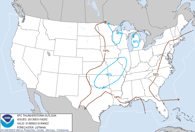
Looking forward, the SPC’s thunderstorm outlook for 4-8pm shows us around a 40% risk for thunderstorms; I believe this is conservative given what we’ve already seen today. From 8pm-midnight, they show us just outside a 40% risk area, and again from midnight-8am; again, I expect thunderstorms in are area at least through midnight.

Thunderstorm Outlook May 31, 2013 4-8pm
Thunderstorm Outlook May 31, 2013 8pm-midnight


Severe thunderstorm for NE Washtenaw county and NW Wayne county cancelled

The storm which promoted this warning has moved out of the area and now threatens only Oakland county. The warning is still in effect until 2pm for Oakland. (This warning never affected Ann Arbor; only the area northeast of A2.)

KGRR composite reflectivity may 30, 2013 1:01pm
WWUS53 KDTX 311703
SVSDTX

SEVERE WEATHER STATEMENT
NATIONAL WEATHER SERVICE DETROIT/PONTIAC MI
103 PM EDT FRI MAY 31 2013

MIC161-163-311713-
/O.CAN.KDTX.SV.W.0034.000000T0000Z-130531T1800Z/
WASHTENAW MI-WAYNE MI-
103 PM EDT FRI MAY 31 2013

...THE SEVERE THUNDERSTORM WARNING FOR NORTHWESTERN WAYNE AND
NORTHEASTERN WASHTENAW COUNTIES IS CANCELLED...

THE STORM WHICH PROMPTED THE WARNING HAS MOVED OUT OF THE WARNED
AREA.

LAT...LON 4244 8343 4243 8366 4247 8367 4287 8356
     4288 8310 4250 8309
TIME...MOT...LOC 1703Z 220DEG 40KT 4250 8346

$$

MIC125-311800-
/O.CON.KDTX.SV.W.0034.000000T0000Z-130531T1800Z/
OAKLAND MI-
103 PM EDT FRI MAY 31 2013

...A SEVERE THUNDERSTORM WARNING REMAINS IN EFFECT FOR OAKLAND COUNTY
UNTIL 200 PM EDT...

AT 100 PM EDT...A SEVERE THUNDERSTORM WAS LOCATED NEAR NOVI...AND
MOVING NORTHEAST AT 45 MPH.

HAZARD...QUARTER SIZE HAIL AND 60 MPH WIND GUSTS.

SOURCE...RADAR INDICATED.

IMPACT...HAIL DAMAGE TO VEHICLES IS EXPECTED. EXPECT WIND DAMAGE TO
        ROOFS...SIDING AND TREES.

THE SEVERE THUNDERSTORM WILL BE NEAR...
 WEST BLOOMFIELD AND ORCHARD LAKE AROUND 110 PM EDT.
 SYLVAN LAKE AND WATERFORD AROUND 115 PM EDT.
 PONTIAC AROUND 120 PM EDT.
 AUBURN HILLS AND ROCHESTER HILLS AROUND 125 PM EDT.
 LAKE ORION AND ROCHESTER AROUND 130 PM EDT.
 OXFORD AROUND 135 PM EDT.

THE WARNING INCLUDES AREAS SURROUNDING THESE LOCATIONS...
 WEST BLOOMFIELD...    TROY...               SOUTHFIELD...
 SOUTH LYON...         ROYAL OAK...          ROCHESTER...
 PONTIAC...            OXFORD...             ORTONVILLE...
 NOVI...               MILFORD...            CLARKSTON...
 BIRMINGHAM...

PRECAUTIONARY/PREPAREDNESS ACTIONS...

FOR YOUR PROTECTION MOVE TO AN INTERIOR ROOM ON THE LOWEST FLOOR OF A
BUILDING.

&&

LAT...LON 4244 8343 4243 8366 4247 8367 4287 8356
     4288 8310 4250 8309
TIME...MOT...LOC 1703Z 220DEG 40KT 4250 8346

HAIL...1.00IN
WIND...60MPH

$$

MANN

Severe storm warning north of Ann Arbor (A2 unaffected)

The cell that passed through Ann Arbor about half an hour ago continued developing and is now severe-warned (as I suspected it would). This warning does not affect Ann Arbor. Warning text follows this radar image.

Screen Shot 2013-05-31 at 1.01.33 PM

WUUS53 KDTX 311652
SVRDTX
MIC125-161-163-311800-
/O.NEW.KDTX.SV.W.0034.130531T1652Z-130531T1800Z/

BULLETIN - IMMEDIATE BROADCAST REQUESTED
SEVERE THUNDERSTORM WARNING
NATIONAL WEATHER SERVICE DETROIT/PONTIAC MI
1252 PM EDT FRI MAY 31 2013

THE NATIONAL WEATHER SERVICE IN DETROIT/PONTIAC HAS ISSUED A

* SEVERE THUNDERSTORM WARNING FOR...
 OAKLAND COUNTY IN SOUTHEAST MICHIGAN...
 NORTHEASTERN WASHTENAW COUNTY IN SOUTHEAST MICHIGAN...
 NORTHWESTERN WAYNE COUNTY IN SOUTHEAST MICHIGAN...

* UNTIL 200 PM EDT

* AT 1248 PM EDT...A SEVERE THUNDERSTORM WAS LOCATED NEAR SALEM...AND
 MOVING NORTHEAST AT 45 MPH.

 HAZARD...QUARTER SIZE HAIL AND 60 MPH WIND GUSTS.

 SOURCE...RADAR INDICATED.

 IMPACT...HAIL DAMAGE TO VEHICLES IS EXPECTED. EXPECT WIND DAMAGE TO
          ROOFS...SIDING AND TREES.

* THE SEVERE THUNDERSTORM WILL BE NEAR...
 NOVI AND NORTHVILLE AROUND 100 PM EDT.
 WALLED LAKE AND FARMINGTON HILLS AROUND 105 PM EDT.
 WOLVERINE LAKE AND COMMERCE AROUND 110 PM EDT.
 ORCHARD LAKE AND WEST BLOOMFIELD AROUND 115 PM EDT.
 SYLVAN LAKE AND WATERFORD AROUND 120 PM EDT.
 PONTIAC AND AUBURN HILLS AROUND 125 PM EDT.

THE WARNING INCLUDES AREAS SURROUNDING THESE LOCATIONS...
 WEST BLOOMFIELD...    TROY...               SOUTHFIELD...
 SOUTH LYON...         SALEM...              ROYAL OAK...
 ROCHESTER...          PONTIAC...            OXFORD...
 ORTONVILLE...         NOVI...               NORTHVILLE...
 MILFORD...            LIVONIA...            CLARKSTON...
 BIRMINGHAM...

PRECAUTIONARY/PREPAREDNESS ACTIONS...

FOR YOUR PROTECTION MOVE TO AN INTERIOR ROOM ON THE LOWEST FLOOR OF A
BUILDING.

&&

LAT...LON 4250 8309 4232 8356 4243 8368 4244 8366
     4247 8367 4287 8356 4288 8310
TIME...MOT...LOC 1653Z 218DEG 37KT 4242 8357

HAIL...1.00IN
WIND...60MPH

$$

MANN

Developing thunderstorms approaching Ann Arbor

A line of developing thunderstorms stretching from Flint south to Saline is moving northeast at 45 mph. One of the stronger cells is expected to arrive in Ann Arbor within 10 minutes. Expect 30+mph wind gusts, 5 minutes of moderate downpour (light rain for much longer), and infrequent lightning.

These storms are not severe right now but will continue strengthening due to the warm moist air throughout the area. They do not represent a severe threat for the city.

KDTX Composite Reflectivity May 31, 2013 12:22pm

Special weather statement issued 12:23pm from NWS Detroit:

WWUS83 KDTX 311623
SPSDTX

SPECIAL WEATHER STATEMENT
NATIONAL WEATHER SERVICE DETROIT/PONTIAC MI
1223 PM EDT FRI MAY 31 2013

MIZ054-055-061-062-068>070-075-076-083-311730-
GENESEE-LAPEER-LIVINGSTON-MACOMB-MONROE-OAKLAND-SANILAC-TUSCOLA-
WASHTENAW-WAYNE-
1223 PM EDT FRI MAY 31 2013

...SPECIAL WEATHER STATEMENT...

AT 1222 PM EDT...NATIONAL WEATHER SERVICE DOPPLER RADAR INDICATED AN
AREA OF DEVELOPING THUNDERSTORMS ALONG A LINE EXTENDING FROM FLINT
TO HOWELL TO SALINE...MOVING NORTHEAST AT 45 MPH.

WINDS GREATER THAN 30 MPH...OCCASIONAL CLOUD TO GROUND LIGHTNING...
BRIEF MODERATE DOWNPOURS...ARE POSSIBLE WITH THESE STORMS.

* THUNDERSTORMS WILL BE NEAR...
 WILLIS AND HAMBURG BY 1230 PM EDT...
 FLAT ROCK AND BELLEVILLE BY 1235 PM EDT...
 TRENTON AND ROMULUS BY 1240 PM EDT...
 MILLINGTON AND TAYLOR BY 1245 PM EDT...
 WYANDOTTE AND SALEM BY 1250 PM EDT...
 LIVONIA AND DEARBORN BY 1255 PM EDT...
 DETROIT AND GRAND BLANC BY 100 PM EDT...

GUSTY WINDS MAY CAUSE SMALL OBJECTS SUCH AS TRASH BINS TO BLOW
AROUND. STAY AWAY FROM HIGH OBJECTS OUTDOORS SUCH AS TREES. SEEK
SHELTER IN A STURDY STRUCTURE UNTIL THESE STORMS HAVE PASSED.

$$

MANN